

Jizera Mountains Hikes: Trips from Jizerka Village
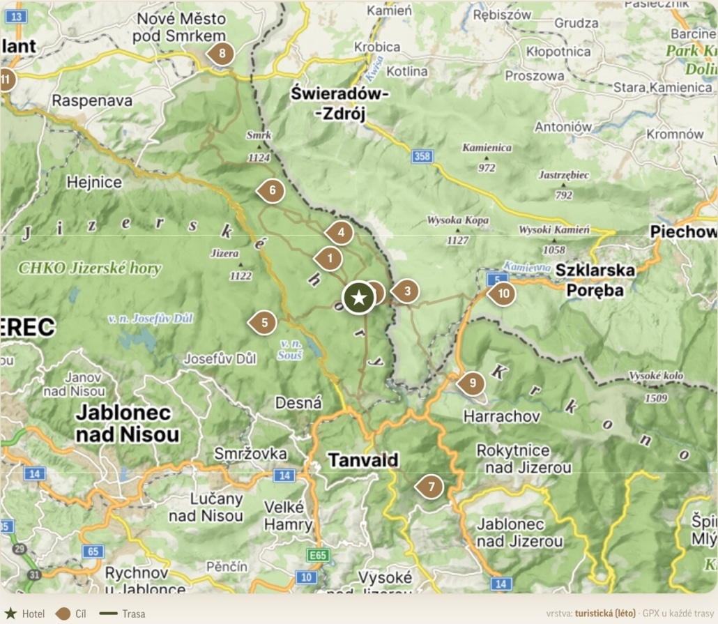
The best walk is the one that starts on your doorstep. And because Jizerka sits right in the heart of the Jizera Mountains — the highest village in the whole range — we’ve put together a new interactive map of walks from Jizerka, where you can pick a route by season, by mood and by whoever happens to be coming with you. From the boardwalk trails across the peat bogs, where children practically walk on water, to the climb up Smrk (the highest peak) with its lookout tower, from which on a clear day you can see a hundred and fifty kilometres into the distance.
We’ve walked every route ourselves. So for each one you’ll find the distance, the elevation gain, whether it works with a pushchair or a dog, and a GPX file to download to your phone. No recycled generalities — just the kind of local knowledge you’d get from someone who lives here. (Last checked in June 2026.)
A map that plans for you: filters, GPX and the seasons
The new walks page isn’t just a list of links. It’s a map where you can filter routes by season and difficulty — summer or winter; a brisk stroll or a full day on the trail; pushchair-friendly, child-friendly or dog-friendly. For each walk you can see the distance and the climb, and download the GPX straight to your watch or phone. By the time you head down to the terrace for breakfast, your day is already planned.
The walk starts at the door: why Jizerka makes the perfect base
Jizerka is the highest village in the Jizera Mountains — it sits at around 850 metres, inside a protected landscape area and right on the main ridge route. That brings one very practical advantage: there’s no driving to a trailhead. The walk begins at the door, and when you come back down off the ridge you step straight onto our terrace or into the wellness centre. A day in the mountains and a soft landing — in exactly that order.
Summer: on foot, with the kids and up into the hills
In summer Jizerka becomes a crossroads. A few steps from the village you’ll find gentle family loops as well as more demanding climbs onto the ridges. Choose from the map of walks depending on how much energy and time you have.
The climb up Smrk
The highest peak of the Czech Jizera Mountains, and a classic that rewards an early start. At the top you’ll find a steel lookout tower with views that, on a clear day, stretch up to a hundred and fifty kilometres — across to the Krkonoše (Giant Mountains), over to Ještěd and deep into Poland. Roughly 16 kilometres there and back; best for fitter families with older children.
The Tři iseriny nature trail
The ideal first walk. The trail sets off straight from the village, leads past the peat bog and the basalt cone of Bukovec, and the panels along the way explain just what makes the Jizera Mountains so special. About six kilometres, doable all year round and a treat for dog walkers too.
The peat bog on boardwalks
The easiest loop for miles around — wooden boardwalks carry you through the heart of the reserve without getting your feet wet. Children genuinely feel like they’re walking on water, keeping an eye out for black grouse and carnivorous sundew plants. Two to three easy kilometres, manageable even with an all-terrain pushchair.
The burst dam on the Bílá Desná
A half-day goal with a story behind it. The dam wall gave way in 1916, and what remains is a striking reminder of it to this day; along the way you pass a Way of the Cross and a slice of Jizera Mountains history. A lovely outing with children and dogs alike.
The Štěpánka lookout tower
The oldest stone lookout tower in the Jizera Mountains, on a loop you can stretch to anywhere from 12 to 16 kilometres — the longer version takes in a few waterfalls and stays pushchair-friendly throughout.
For the active: cycling, singletrack and the ridges
Anyone keen to really push themselves is perfectly placed in Jizerka for the best the mountains have to offer, whether on two wheels or two feet.
Singltrek pod Smrkem
The very first singletrack network in the Czech Republic — over 90 kilometres of narrow trails graded across four levels, from green for beginners to black for the hardened. It suits children from the age of five right up to seasoned riders.
Down the Jizera valley to Harrachov
A trip along the Czech-Polish border with a chance to swim in the river on the way. Around 25 kilometres by bike, and shorter on foot; one for fitter families and easy-going souls in no rush to get anywhere.
The Great Jizera Meadow and the Polish Jizera Mountains
A cross-border adventure out to the lost settlement of Gross Iser. Wide-open meadows, silence and the feeling of being at the end of the world — it’s at its best in summer and autumn.
Spring in Jizerka: wild daffodils and globeflowers
For just a few weeks in the second half of May and into June, the meadows around Jizerka turn into a yellow sea of wild daffodils, and the protected globeflowers come into bloom. It’s the most photogenic spring in the Jizera Mountains, and there’s only one thing to say about it: it’s now or never. Arrive a fortnight later and all you’ll see is grass — all the more reason to make it happen this year.
Winter: cross-country skiing straight from the village
In winter you clip into your cross-country skis right outside the door. The Jizera ski highway runs directly through Jizerka, with over 170 kilometres of groomed tracks — from short family loops to full-day ridge crossings. This is the home ground of the legendary Jizerská 50 race, and thanks to the altitude the snow lingers here long after it has melted elsewhere.
Which routes suit whom
- Families with children: the peat bog on boardwalks, the Tři iseriny nature trail, Štěpánka.
- Hikers and ridge-walkers: Smrk, and the loops across the Great Jizera Meadow.
- Cross-country skiers: the Jizera ski highway, straight from the village.
- Nature lovers: the spring daffodils and globeflowers, and the peat bogs.
- Couples: a shorter loop and the terrace or wellness centre in the evening.
Don’t fancy sifting through it all by hand? Let the map find the right walk for your group — tick who you’re walking with and which season it is, and you’re left with only the routes that make sense.
Practical info: parking, distances, pushchairs
There’s paid parking on the edge of the village; in peak season and at weekends we’d recommend arriving in the morning, when there’s the most space and the fewest people on the trails. Read the distances and elevation gains off the map — the figure beside each route is always the full there-and-back distance, or the length of the loop. With an all-terrain pushchair you’ll manage both the peat bog and the longer Štěpánka loop; for Smrk and the singletrack, a child carrier is the safer bet. And if the rain comes in, that’s not the end of your day — you can always take shelter with us, in the wellness centre or over breakfast or a late lunch.
Frequently asked questions
Where can I park near Jizerka village?
At the paid car parks on the edge of the village. At weekends and in peak season it pays to arrive in the morning.
Where does the Tři iseriny nature trail start?
Right in Jizerka village; you can join it easily, straight from your accommodation.
Can you walk from Jizerka into Poland?
Yes. Crossing the border brings you to the Polish settlement of Orle and to Hala Izerska — a popular cross-border loop.
What is the highest village in the Jizera Mountains?
Jizerka itself — it lies at around 850 metres above sea level.
When do the daffodils bloom in Jizerka?
Usually in the second half of May and into June; the exact window shifts from year to year with the weather.
How long is the Jizera ski highway, and does it run through Jizerka?
Over 170 kilometres of groomed cross-country tracks — and yes, it runs right through the village.
Set off straight from our door
These routes are best walked when you’re staying right at the start of them. Stay in Jizerka, sleep in the quiet, and in the morning head out straight from the door. In the meantime, you can open every route with its GPX and pick the one that’s yours.

